Misfat al Abriyeen or with it’s short name Misfah, is an old mountain village consisting of historical houses of extraordinary architecture with ancient stone buildings and narrow streets perched in a valley amidst rocky mountains and date palm gardens.
It lies at the foot of Jabal Shams at a distance of 5 km from the city centre of Al Hamra in the Al Dakhiliyah governorate. It is well connected by roads and is accessible to all kinds of vehicles.
Misfah abounds in greenery and date palms. The falaj system in Misfah is fascinating since the water weaves its way in a snakelike fashion along the mountain side, special channels in turn redirect the water down to different levels of the gardens. The first thing that draws your attention here is the agricultural terraces, which extend from the source of the Falaj and to even very long distances. The most important agricultural crops are date palm trees, bananas and citrus fruits. Because of its unique setting and medieval appearance it became one of the most important tourist destinations in Oman.
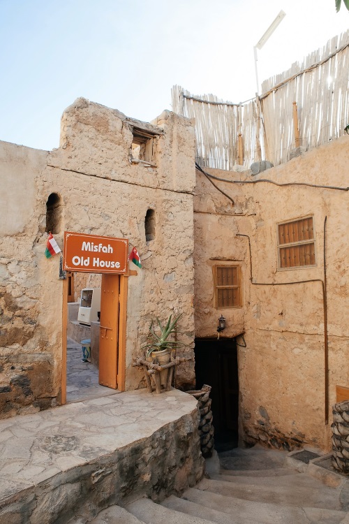
Misfah Old House is placed in the middle of the old village of Misfat Al Abryeen where local people are mainly farmers. Our Misfah Old House is about 220 km from Muscat airport and is very easy to reach. It is about 40 km north-west from Nizwa city (GPS location of the house is 23.139800, 57.312350). The houses have 12 rooms with 8 shared bathrooms. The hotel is run and operated by a respected Misfah family, who speak well English and have more than 5 years experience in hospitality. Dinner and Breakfast is usually taken on the lovely roof terazze allowing magnificent views of the surrounding palm tree gardens and mountains You will feel like being in an Omani house between Omani people. We promise you an unforgettable and charming stay in the lovely village of Misfah.
As Misfah is still a very traditional place we kindly ask you to respect the following:
1. Smoking is not allowed inside the house (please ask for the smoking area).
2. Alcoholic drinks are not allowed at all by Oman Government law.
3. Please make sure you wear decent clothes when you walk in the village. (covered shoulders for ladies and no shorts)
4. Carry only a small luggage for the stay in the house, as you have to walk for 5min to get to it.
5. Check In time should be before 5 pm as you need to walk for almost 5 min to the house and there is no street lighting, so better doing this in day light.
THINGS TO DO
Nearby points of interest are the old village of Misfah, Al-Hoota Cave (a big natural cave near Al-Hamra town about 20 minutes drive from our house), Al-Hamra old village, Bait Alsafah, a traditional museum, Jabal Shams ( the highest mountain in the gulf more than 3000 m high), Jabreen Castle and Nizwa city with the Nizwa Fort with it's huge defense tower and the traditional Nizwa market with its Silber souk and on Fridays animal market.
Misfah Culture Tour (approx 2.5 hours)
The tour can be done after breakfast or at afternoon time. The local guide will take you to explore the Omani life in the past and the culture and traditional life of the village at present. Also there is time to show you the irrigation system and the water distribution. You can also enjoy watching the people working in their garden doing the daily work with explanations from our guide about the agriculture aspect in the village. By the end of the tour you will be able to understand the Omani traditional life in the old days .
Misfah Agriculture Tour (approx 4 hours)
The tour can be done after breakfast or at afternoon time. You are going to join a local farmer in his daily work, our guide will explain to you the type of work and also you can do some work as well if you are interested. The farmer will show you the traditional tools for farming and how to use them. The variety of farm products and the seasonal fruits will be part of the tour.
Half Day Trekking tour (approx 5 hours)
After breakfast we will take you to explore the surrounding mountains of the village, using the well worn paths of the old days. You will pass through gardens and slowly you will raise above to have a wonderful view of the old village and the water spring. You can enjoy the warmth of the sun at early morning. After that we will start to climb up till you have an open view of the village from the higher levels. After some more walking you will reach little houses belonging to a goat keeper where you will have a cup of coffee with the inhibitants. Then continue walking to the next village and turn back to Misfah. Along the return path there will also be nice views of Al-Hamra. After that you will be back to the house enjoying a chance to meet the people with donkeys coming back from the village and clamping up with stuff for their family’s.
Full Day Trekking Tour (approx 6 hours)
After breakfast we will take you for a long trek following an ancient donkey path in the Western Hajer mountains .The tour allows spectacular views of Wadi Bain Awf and the surrounding mountains. The car will wait for you at the end of the route to bring you back to Misfah.
2 Days Donkey Trekking
Day 1 - After breakfast we will start to walk along with donkeys from the village of Misfah at 900m ASL, climbing up towards Birkat Al-Sharaf at 2000m ASL first passing through the green gardens of Misfah, then crossing the Wadi and trekking up to Aqba Al-Hamra, a small hamlet. The route is taking you further up, while the sun light reflects in the mountains. We reach Birkat Al-Sharaf after approximately 5 hours of walking with donkeys. After arrival we will set up our camp at 2000m - in the afternoon you can explore the area and enjoy the views down the north face of the Al Hajar mountains (wadi Al Sahtan). Overnight will be in tents or if preferred under the stars.
Day 2 - After breakfast we will start to walk towards east along the ridge of the mountain till Sharaf AL Alamyn at 2000m ASL, along the path you will enjoy the views towards Wadi Al Sahtan and Wadi Bani Awf with it’s villages. The walk will be for around 5 hours without donkeys since the path is not suitable for them. A car will bring you back to Misfah.
Other Daily Tours to Other Attractions in the Region
We are happy to arrange for you other day trips to explore the area such as: Jabel Shams, Bahla fort, UNESCO Heritage site and town, Jabreen Castle, Nizwa and Jabel Akhdar, Bat UNESCO heritage site and others. Just request your destinations and we will arrange it for you.
For any more information please don’t hesitate to contact us at any time at email……….
General Information
Oman
Officially called the Sultanate of Oman, is an Arab state in southwest Asia on the southeast coast of the Arabian Peninsula. It has a strategically important position at the mouth of the Persian Gulf.
| Official Name |
Sultanate of Oman |
| Head of State |
His Majesty Sultan Qaboos bin Said (since 1970) |
| Currency |
(O.R): OMANI RIALS. (1US$=0.385 O.R ; 1Euro= 0.498 O.R as on 19/03/2013 |
| Capital |
Muscat |
| Main Cities |
Nizwa, Sur, Izwa, Sur, Salalah, Sohar |
| Population |
3,311,640 including 577,293 expatriates (July 2007) |
| Total Surface |
309,500 Km 2 |
| Neighbouring Countries |
Yemen Arab Republic, Kingdom of Saudi Arabia and the United Arab Emirates. |
| Time |
GMT + 4 hour |
| Religion |
Islam |
| Language |
ARABIC is the native language of the country. However, English is widely spoken (as a second language). Some involved in tourism speak German & French |
| Credit Card currently used |
Visa, Master Card, American Express... All major credit cards are accepted in main hotels, stores, and most shops but in traditional souks, cash is the most preferred means for transactions. |
| Public Holidays |
Renaissance Day (1day): 23 July, National Day: 18 November |
| Area |
309,501 km2 (70th) or 119,498 sq mi |
| |
|
| Business Hours |
Government offices from 8.00 – 14.30 Saturday to Wednesday.
Banks 8.00 – 14.00 Sunday to Thursday
Shops 9.00 to 13.00 and 16.00 to 22.00 |
| Dialing Code |
+968 |
| |
|
| |
|
OMAN with its unique and strategic location on the southern tip of the Arabian peninsula, Oman is one of the most attractive travel destinations in the Middle East, a country that combines luxurious comfort and safety a midst rugged mountains, panoramic beaches, and striking desert escapes.
The topography is varied, with rugged mountains and rocky deepwater fjords to the north, the mountains and green hills of Dhofar region to the south, and the spectacular dunes of the Wahiba sands in the center, Oman is a marvelous symphony, harmonizing a great civilization and modern development. Oman is an attractive concept of tourism presenting culture, arts, heritage, nature, sports, adventure, entertainment and knowledge.
Location
The Sultanate of Oman is situated on the southeast corner of the Arabian Peninsula and is located between Latitudes 16° 40' and 26° 20' North and Longitudes 51° 50' and 59° 40' East.
The coastline extends 1,700 Km from the Strait of Hormuz in the north, to the borders of the Republic of Yemen in the south and overlooks three seas: the Arabian Gulf, Gulf of Oman and the Arabian Sea.
The Sultanate borders Kingdom of Saudi Arabia in the West; the United Arab Emirates in the Northeast, the Republic of Yemen in the South; the Strait of Hormuz in the North and the Arabian Sea in the East.
The Musandam Peninsula forms the country's northern tip, and is separated from the rest of the Sultanate by United Arab Emirates' eastern coast and includes the only coast the Sultanate has on the Arabian Gulf.
Musandam is just over 50 Km (30 miles) south of the Islamic Republic of Iran across the Strait of Hormuz.
The total land area is around 309,500 Km2 and it is the third largest country in the Arabian Peninsula.
Topography
Oman possesses a rich diverse topography ranging from rugged mountains and rocky deepwater fjords in the North, to the spectacular dunes of Sharqiyah (Wahiba) Sands and two large salt flats in the centre, to the lush green hills of Dhofar region in the South, with rugged coasts and placid beaches stretching along the 3,150.00 Km coastline.
The northern coastal strip along the Gulf of Oman is known as the Batinah Coast; a narrow fertile plain separated from the rest of the country by the Hajar Mountains. The highest peak is Jabal Shams (Sun Mountain) at 3,075 m. The southern slopes of the range are notable for their oasis towns where date groves flourish in the dry desert air.
In the south lies the second mountain range in Oman; the Qara Mountains, which attracts the light monsoon rains during the mid-summer months, turning them green with vegetation whose roots help delay the effects of erosion resulting in a soft rolling landscape more akin to central Africa.
As in the north, a narrow fertile coast plain lies between the mountains and the sea at whose centre Salalah lies, surrounded by lush vegetable farms and coconut groves.
Climate
The varied geography of the Sultanate results in a wide variety of climatic conditions. Although lying in the tropics, the Sultanate is subject to seasonal changes like the more temperate regions of the world.
The hottest months are June through August. The summer monsoon just touches the southern coast of Dhofar during these months bringing regular light rain to Salalah and reducing the average daytime highs to 30° C.
The most pleasant months to visit Oman are mid October through March when daytime temperatures fall into the lower 25s and below.
Rainfall varies but in general remains sparse and irregular. In the south most of the year's rainfall occurs during the summer monsoon months. In the north the opposite occurs. Here most rain comes from occasional winter storms which descend out of the eastern Mediterranean during the months of January through March, depositing an annual average of 10 cm of rain on the capital area.
Administrative Regions
The Sultanate is divided into eight administrative regions
Each of these is subdivided into smaller districts called Wilayats, which are governed by the Wali, the person responsible for administrating the area and reports to the Minister of the Interior.